ගොනුව:Map prevailing winds on earth.png
Jump to navigation
Jump to search

මෙම පෙරදසුනෙහි විශාලත්වය: 800 × 351 පික්සල. අනෙකුත් විභේදනයන්: 320 × 140 පික්සල | 640 × 281 පික්සල | 1,425 × 625 පික්සල.
මුල් ගොනුව (1,425 × 625 පික්සල, ගොනු විශාලත්වය: 157 කි.බ., MIME ශෛලිය: image/png)

|
This meteorology image could be re-created using vector graphics as an SVG file. This has several advantages; see Commons:Media for cleanup for more information. If an SVG form of this image is available, please upload it and afterwards replace this template with
{{vector version available|new image name}}.It is recommended to name the SVG file “Map prevailing winds on earth.svg”—then the template Vector version available (or Vva) does not need the new image name parameter. |
සාරාංශය
| විස්තරය |
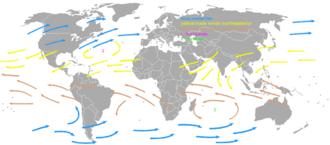
English: A map showing the prevaling winds on Earth. The image was made based on an image in the book "Het handboek voor de zeiler" by H.C. Herreshoff. |
| දිනය | |
| මූලාශ්රය | ස්වයං නිර්මාණයකි |
| කර්තෘ | KVDP |
බලපත්රීකරණය
| මම, මෙම කාර්යයේ ප්රතිරූපණ අයිති හිමිකරු, මෙම කාර්යය public domain වෙත නිදහස් කරමි. මෙය ලෝක ව්යාප්තව අදාළ වේ. සමහර රටවල මෙය අනීතික විය හැකිය. එසේ වුවහොත්; මම කිසිදු කොන්දේසියකින් තොරව,ඕනෑම අයෙකුට ඕනෑම කාර්යයක් සඳහා මෙය, නීතිමය බාධාවක් නොමැති වනතුරු, භාවිතා කිරීමේ අයිතිය ලබාදෙමි. |
ගොනු ඉතිහාසය
එම අවස්ථාවෙහිදී ගොනුව පැවැති ආකාරය නැරඹීමට දිනය/වේලාව මත ක්ලික් කරන්න.
| දිනය/වේලාව | කුඩා-රූපය | මාන | පරිශීලක | පරිකථනය | |
|---|---|---|---|---|---|
| වත්මන් | 14:54, 5 මාර්තු 2012 | | 1,425 × 625 (157 කි.බ.) | wikimediacommons>Genetics4good | Yellow northeasterly arrow changed with a blue west-southwesterly arrow in the area of the Dakotas; as requested by Thegreatdr |
ගොනු භාවිතය
පහත දැක්වෙන පිටුව විසින් මෙම ගොනුව භාවිතා කෙරෙයි: